|
|
The first written reference
to the village of West Hagbourne is found in the Domesday Book.
In 1086, a year before he died and after nearly twenty years on
the English throne, William of Normandy ordered a survey of the
land he had conquered in 1066. William's survey registered all
arable land, meadows and woodland, the names of the manors, the
number of villeins and freemen and the amount of land they held,
the mills and the value of the estates. This was done in considerable
detail, right down to the number of ploughs and the amount of
land held by each freeman.
For the purpose of the survey, villages were grouped by administrative
districts called Hundreds, which formed regions within shires
or counties. At the time of the Domesday Book, West Hagbourne
lay in the Hundred of Blewbury (Blitberie) in the county of Berkshire
(Berchescire).
Although the Domesday Book entry for West Hagbourne is brief,
it is a rich source of information, indicating the size and value
of the manorial estate and providing a glimpse of the feudal structure
of the village community. The following entry is from a translation
of Abraham Farley's 1783 printed text of the Domesday Book.
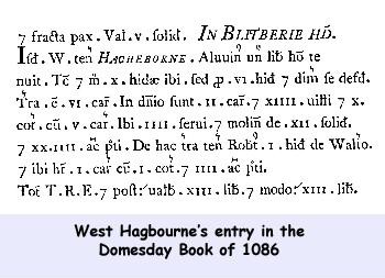 In
BLEWBURY hundred Walter also holds (West) Hagbourne. Alwin, a
free man, held it. In
BLEWBURY hundred Walter also holds (West) Hagbourne. Alwin, a
free man, held it.
Then and now 10 hides there, but it answers for 6½ hides.
Land for 6 ploughs. In lordship 2 ploughs; 14 villagers and 10
cottagers with 5 ploughs.
4 slaves; a mill at 12s; meadow, 24 acres.
Robert holds 1 hide of this land from Walter; he has 1 plough,
with 1 cottager; meadow, 4 acres.
Value of this whole before 1066 and later £13; now £13.
West Hagbourne appears to
have been a typical medieval English village organised around
a manorial system based on Anglo-Saxon serfdom. The first manor
house of West Hagbourne stood on the site of Manor Farm, slightly
apart, at one corner of the village, as was the custom at the
time. It is believed that it once had a moat. Until the Reformation,
West Hagbourne had its own chapel not far from the manor.
In 1086 West Hagbourne boasted ten hides and 24 acres of meadow,
some of which would have been common land used by the tenants
to graze their livestock. The lord of West Hagbourne had two ploughs
for farming the demesne land and two slaves (serfs) to work each
plough, whilst the villagers had five ploughs between them. He
held jurisdiction over 14 villagers (villeins) and their families.
In addition to the 14 villagers and four slaves, there were ten
cottagers (cottars) attached to the manor.
West Hagbourne's assets included a mill, which is known to have
still been in existence during the reign of Henry VIII, although
its exact site is not marked on any surviving maps. The mill would
have been driven by one of the many streams or 'bournes' from
which Hagbourne derives its name.
It was not unusual for a parish to have more than one manor and
West Hagbourne was no exception. The second manor was called Watlingtons
and stood on the site of the present Grove Manor Farm. The origin
of Watlingtons is not as well documented as the history of the
Windsor manor and the source of the name remains unknown. 'The
Victoria History of Berkshire' suggests that Watlingtons could
have been the hide of land referred to in West Hagbourne's entry
in the Domesday Book:
Robert holds 1 hide of this land from Walter; he has 1 plough,
with 1 cottager; meadow, 4 acres.
The hide which Robert rented from Walter was farmed independently
of the rest of the manorial land as Robert had his own plough,
a cottar to labour for him and a further four acres of meadow
for grazing. This land continued to be regarded as a separate
holding as subsequent documents relating to land transfers all
identified it as distinct from the Windsor manor, even when both
were held by the same lord.
|